


ouigt 1

robert gallet
User
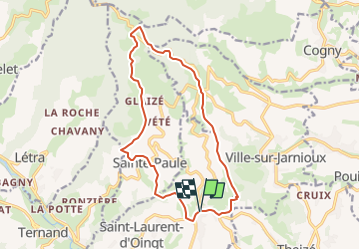

Length
15.2 km

Max alt
763 m

Uphill gradient
587 m
Km-Effort
23 km

Min alt
351 m

Downhill gradient
588 m
Boucle
Yes
Creation date :
2024-08-24 09:00:15.942
Updated on :
2025-05-29 06:17:32.534
5h13
Difficulty : Very difficult

FREE GPS app for hiking
 SityTrail
IGN / Geographical institutes
SityTrail Plus
The world is yours!
About
Trail Walking of 15.2 km to be discovered at Auvergne-Rhône-Alpes, Rhône, Val d'Oingt. This trail is proposed by robert gallet.
Positioning
Country:
France
Region :
Auvergne-Rhône-Alpes
Department/Province :
Rhône
Municipality :
Val d'Oingt
Location:
Oingt
Start:(Dec)
Start:(UTM)
622685 ; 5089626 (31T) N.
Comments